Remote Sensing Strategies to Monitor British Columbia’s Glaciers
Bridge Glacier complex on the Lillooet Icefield, British Columbia. Photo: Mary Sanseverino
British Columbia is blessed with an abundance of glaciers, or about 16,428 individual ice masses based on the last provincial inventory.[1] These glaciers act as important buffers for many mountain ecosystems since they provide cool, plentiful water to mountain rivers during late summer when the seasonal snowpack is depleted. This buffering capacity is especially important during years of drought.
Table 1. Regional mass balance and total mass loss for glacierized regions of western Canada. Click to enlarge.
Variations in winter snowfall or temperatures during the melt season lead to changes in ice thickness, area, and volume. Monitoring glacier change thus provides one way to directly assess the severity and spatial pattern of climate change on mountain environments. The blessing of ‘glacier plenty’ in British Columbia can, at first glance, also appear to be a curse: How does one effectively monitor the province’s many thousands of glaciers?
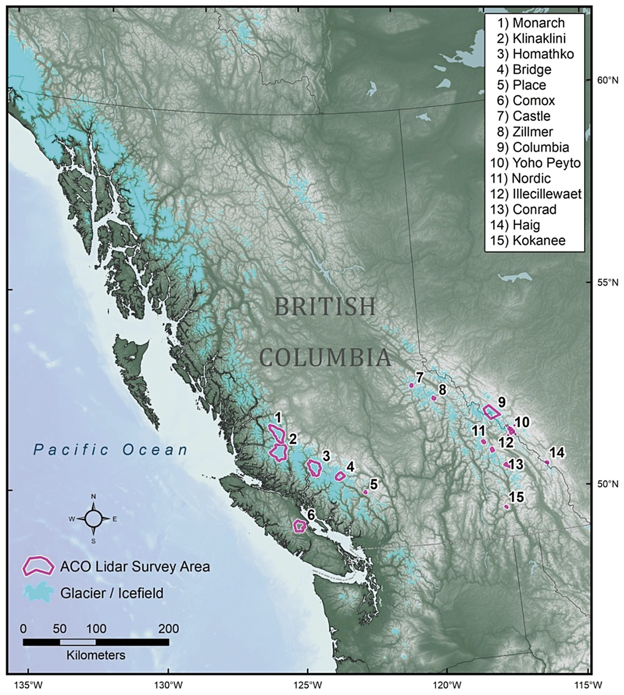
Most glacier monitoring studies measure (i) surface mass balance – how much water is lost or gained by a glacier over some interval of time,[2] or (ii) changes in areal extent.[3] Surface mass balance provides the most direct link to meteorological forcing, but these measurements are few and not well distributed in time and space. In western Canada, for example, mass balance records that exceed fifty years in length exist for only Place and Peyto glaciers, and both glaciers are small (< 10 km2) and located south of 52 deg N (Fig 1). Geodetic mass balance affords a more representative snapshot on glacier health as they can sample hundreds to thousands of individual glaciers within a single acquisition. This technique measures elevation change over some interval of time, and, when multiplied by a representative estimate of density, elevation change can be converted to mass change. Using spaceborne stereoscopic imagery, a study showed that mass loss from British Columbia glaciers, excluding those that straddle the BC-Alaska border, accelerated over the last decade (2009-2019) losing about four -five times more mass than the previous decade.[4] A more recent study confirms this accelerated mass loss in this region and elsewhere in the mountains of western Canada (Table 1).[5]
Fig 1. Glacierized terrain of British Columbia. Pink polygons denote glaciers, glacierized regions and icefields currently surveyed by the Airborne Coastal Observatory. Map produced by Keith Holmes (Hakai Institute). Click to enlarge.
Bridges between space and surface observations
Fig 2. Geodetic (airborne LiDAR) versus glaciological mass balance in metres of water equivalent [m w.e.] over the period 2015-2019 for glaciers in the interior ranges (Fig. 1). Blue, grey and red respectively denote winter, net and summer balance. Modified from Pelto and others.[2]. Click to enlarge.
The number, type, and revisit frequency of spaceborne sensors will only increase our ability to regularly monitor British Columbia glaciers and how they respond to changes in climate. Yet persistent cloud cover or the need to acquire high resolution (< 5 m) surface elevation models often hinders space borne data acquisition. Airborne remote sensing can serve as a reliable bridge between space- and ground observations. The Airborne Coastal Observatory (ACO) – a scientific venture between the Hakai Institute and the University of Northern British Columbia – provides one example of a platform that can reliably measure seasonal mass balance of glaciers (Fig 2). The ACO platform consists of a dedicated fixed-wing aircraft, dual air photo cameras, and Light Detection and Ranging (LiDAR) and hyperspectral sensors. The LiDAR sensor allows detailed surface elevation mapping across large areas whereas the hyperspectral sensor can image glacier surfaces across the visible and near infrared portions of the electromagnetic spectrum. Hyperspectral data provide important information about changes in the reflective properties of snow and ice-covered surfaces – a key feature that influences surface melt. Over the last several years the ACO has acquired LiDAR for hundreds of individual glaciers throughout western Canada (Fig 1), including last year when Covid restrictions prevented field visits to Peyto and Place glaciers.
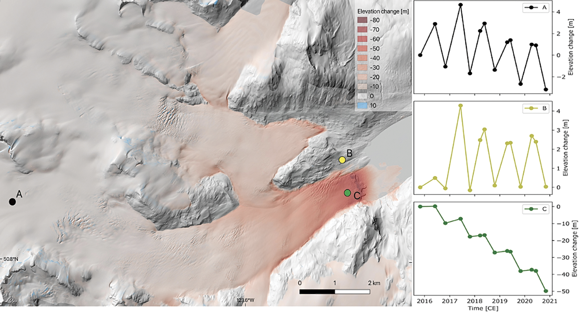
Fig 3. LiDAR-based elevation change [m] of Bridge Glacier over the period 2015-2020. Rightmost panels show elevation change from September, 2015 for pixels in the accumulation (A), stable terrain (B) and glacier terminus (C) regions. Elevation change for (A) and (C) include seasonal snow accumulation (B), changes in mass loss or gain at the surface and ice dynamics that acts to submerge (A) or emerge (C) snow and ice. Time series derived by temporally stacking 13 LiDAR elevation models. Over the period 2015-2020, average thinning of the glacierized terrain was -1.6 m water equivalent (w.e.) which represents a total mass loss of -0.5 Gigatons (1x10⁹ kg).
Temporal stacking
Air- and spaceborne remote sensing can be used to study glaciers, but it can suffer from incomplete sampling in time or space. Commonly, glacier change studies employ ‘epoch-analysis’ where elevation or area change is calculated over some period of time. While useful, this approach may provide a biased view since rates of mass, elevation, or area change largely depend on acquisition dates. How does one compare average thinning rates [m/yr] from Northern Coast Mountains glaciers over the period 1990-2000 to thinning rates from glaciers in the southern Rocky Mountains over the period 2000-2010? Does a larger rate in the south reflect a change in climate forcing for both regions?
Access to huge volumes of remotely-sensed data is quickly making epoch analysis obsolete. Early work on British Columbia glacier mass loss, for example, reported temporally- weighted estimates of mass loss to account for differences in acquisition of aerial photography. [6] More recent studies employed temporal stacking of DEMs obtained from optical satellite imagery to robustly estimate elevation change through elevation trend analysis for any given location on a given glacier.[7] Given sufficient resolution in time and space, temporal stacking also allows processes of accumulation, melt or ice dynamics to be investigated in ways that were unimaginable even a decade ago (Fig 3).
One of the ACC’s newest huts is gifted with a special name, from local First Nations: Hišimy̓awiƛ (Hi-SHIM-ya-wit) it’s called, meaning “Gather Together” in the Barkley Sound dialect of the Yuułuʔiłʔatḥ (Ucluelet) First Nation. Hišimy̓awiƛ sits on the flank of 5040 Peak on Vancouver Island. Photo: Mark McKeough, courtesy of Tristan Oliver.
In addition to providing insight into the current state of health for glaciers in British Columbia, observations of mass and area loss are required to improve physically-based models that simulate the response of glaciers to future climate change. Continued acquisition of air- and spaceborne observations will continue to provide a rich dataset required to assess both the current state and fate of a key natural resource.
Acknowledgments
Financial support provided by Hakai Institute, BC Hydro, Canada Research Chairs Program and National Sciences and Engineering Research Council of Canada. Keith Holmes (Hakai Institute) and Ben Pelto (UBC) respectively prepared figures 1 and 2. Romain Hugonnet provided data to produce Table 1.
Authors
Brian Menounos is a professor of Earth Science and the Canada Research Chair in Glacier Change at the University of Northern British Columbia. In 1987, he fell in love with mountains during an exchange year in Germany and has been studying them ever since. Brian is a Hakai Affiliate and Chief Scientist of the Airborne Coastal Observatory described above.
References
[1] Bolch, T., Menounos, B. & Wheate, R. Landsat-based inventory of glaciers in western Canada, 1985–2005. Remote Sens. Environ. 114, 127–137 (2010).
[2] Pelto, B. M., Menounos, B. & Marshall, S. J. Multi-year evaluation of airborne geodetic surveys to estimate seasonal mass balance, Columbia and Rocky Mountains, Canada. Cryosphere 13, (2019).
[3] Bolch et al (2010).
[4] Menounos, B. et al. Heterogeneous Changes in Western North American Glaciers Linked to Decadal Variability in Zonal Wind Strength. Geophys. Res. Lett. 46, 200–209 (2019).
[5] Hugonnet, R. et al. Accelerated global glacier mass loss in the early twenty-first century. Nature 592, 726–731 (2021).
[6] Schiefer, E., Menounos, B. & Wheate, R. Recent volume loss of British Columbian glaciers, Canada. Geophys. Res. Lett. 34, L16503 (2007).
[7] Menounos, B. et al (2019).


